Ancient Kells
Kingdom of Ossory
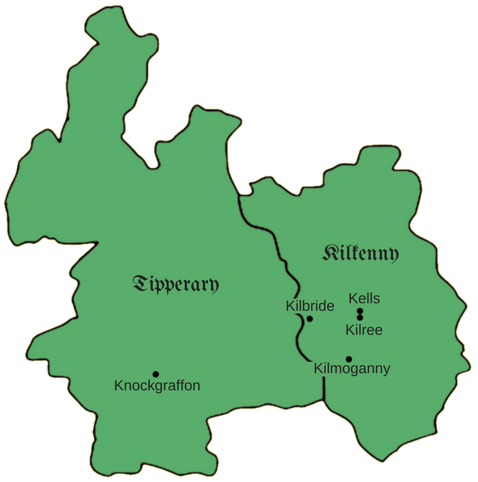
Established in the 5th century, Osraige (Ossory) was a powerful Irish kingdom which comprised most of Kilkenny, and Western Laois. Under Brehon Law, it was divided into Magha (plains), and later into cantreds and baronies.
The Barony of Kells lay within two Magha; Magh-Lacha and Magh-Roighne. Magh-Lacha stretched from the church of Kilree, to the chapel of Kilbride (2 miles SW of Callan), with its southern boundary at the base of the Kilmoganny Hills. Magh-Roighne was south east of the Kings River and stretched as far as Knockgraffon, Tipperary.
How Kells got it's name
Overlooking the plain of Magh-Roighne was the hill of Roighne, on which the King of Ossory held an establishment. From this establishment was derived the word cean (head/capitol) and lios (fort/stronghold). This word "ceanlios" was referred to as Kenlis in Latin and modernised into Kells which became the name of the barony and the town.
High King of Ireland drowns in Kells
In the middle of the 9th Century, Niall Caille, High King of Ireland, invaded Ossory at the head of a numerous army in an attempt to place the Ua Faeláins upon the throne of Leinster. In 844AD, the King and his army had been travelling from Ennisnag along the Callann (now the King's River) when they arrived just outside the townland of Kells. They proposed to cross the river from here into Rathduff, using the most ancient ford of this river. It is said that a servant of the King got into difficulty and that Caille entered the water on horseback in an effort to save them. Unfortunately for the King, he too fell victim to the river and drowned.
The King is believed to have been buried at Cill-Bhrighde Major two miles south of the river. Henceforth, this church became known as Kilree, from the Irish, Cill Righ (Church of the King). The Callann was also renamed, becoming the King's River. Around 950 AD, a large stone cross was placed at Kilree, marking where the King now lies.
The Lost Town of Kells
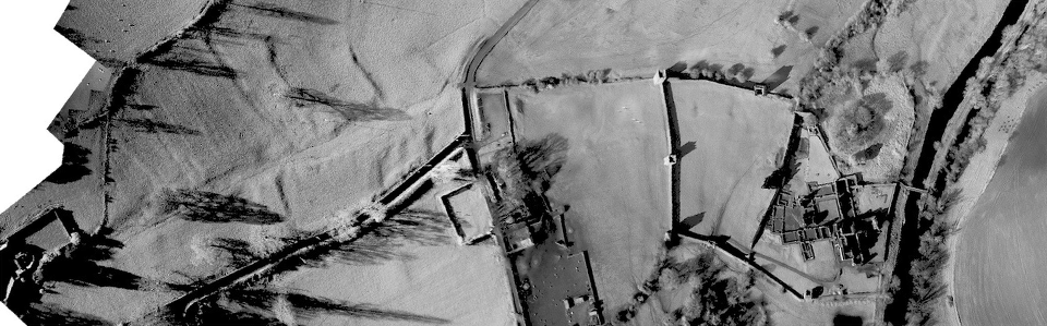
In medieval times, the town of Kells would have been much bigger. A large thriving market town, it would have been heavily reliant on Kells Priory. Through the use of aerial photography, we can examine the earthworks and see the outlines of the medieval town of Kells. It is all but gone but it's mark on the landscape is still there to be seen. In the picture above (top), the priory (right) and the lost town (left) can be seen. It is easy to see the outline of what would have been the main street and how the lines that spur off from it would have been burgage plots (as can be seen at Rothe House, Kilkenny City) and slip streets.
It is also likely that there was a settlement on the site of the present village. In the mid-20th century, at the current garage, oil tanks were hoisted into two recesses that were believed to have been there for hundreds of years, suggesting a streetscape. It is also said by locals that there was a tunnel running from this spot towards the priory.
The lost town of Kells is just one of a number in the area, including; Early (6 minutes away), Stonecarthy (7 minutes away), and of course 'The Lost Town of Newtown Jerpoint' (10 minutes away). To have four in such close proximity is quite unusual.
We would expect that there is a lot of information still locked away in the ground and that an archaeological investigation or ground-penetrating radar, would reveal the town layout. The lost town of Kells shows many parallels to 'The Lost Town of Newtown Jerpoint', which was surveyed in 2007 and only recently opened to the public as a tourist attraction in 2011.
Market Cross
A small surviving remnant of the lost town is the base of it's Market Cross. This would have been at the epicentre of the town and would have been an important landmark around much trade would have taken place. It no longer holds it's pillar, nor cross and there is no knowledge to the design of either.
The cross was erected after the English had taken possession of the town to mark 'The Exaltation of the Holy Cross' on the 14th of September, the chief festival of Kells. Although it is unclear when the cross was removed, we do know that it was still there c.1655 after appearing in the 'Down Survey of Ireland', proving it survived Cromwell's visit to the town.
According to 'History and Antiquities of the Diocese of Ossory', the base is now only "a few yards distant from the spot on which it was first set up many centuries ago" and the aerial photography backs this up.
From the 3D model which was kindly created for us by Simon Dowling, we were able to view detail surrounding the base of the cross that was not visible with the naked eye. Our initial observations of the weathered carvings lead us to believe the pedestal portrays a number of birds, but it will require further study for confirmation. The round base is an unusual feature and there are few surviving examples, another being an 8th century high cross at Kilkieran, Kilkenny.
Historic Kells is currently carrying out research on the cross in the hopes that a replica can be built and that the original can be safely housed inside a museum to protect it from further weathering and damage.